
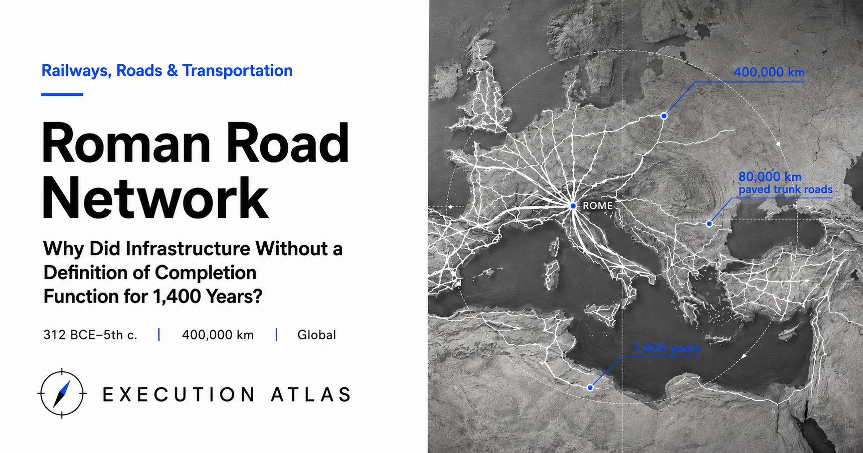
Total length: approximately 400,000 km. Ten times the circumference of the Earth. Exceeding the distance to the Moon at 380,000 km.
Of that, roughly 80,000 km were paved trunk roads — 8.6 times the total length of Japan’s expressway network. This is the scale of ancient Rome’s road system.
It began with the groundbreaking of the Appian Way in 312 BC. It was never completed. Expansion continued into the 4th century, seven hundred years later. Construction stopped with the fall of the Western Roman Empire in the 5th century, but maintenance continued throughout the Middle Ages. Many trunk routes survive today as the alignments of modern highways.
Infrastructure that functioned for 1,400 years without ever defining “completion.” How was it designed, and how was it operated?
Mission: A Project That Began as Military Roads
In 312 BC, Rome was in the midst of the Second Samnite War. The conflict with the Samnites, a mountain people of central Italy, was entering its twentieth year, and the front was pushing south.
That year, Appius Claudius Caecus was appointed censor of Rome. The censor was normally an 18-month office responsible for census-taking and public morals. Without waiting for Senate approval, Appius unilaterally broke ground on two massive projects.
Rome’s first major aqueduct, the Aqua Appia.
Rome’s first long-distance paved road, the Via Appia.
The purpose of the road was explicit: transporting legions to the Samnite front. From Rome to Capua: 212 km. The existing roads were dirt tracks where ox-carts sank in mud, halting army movements in the rainy season. Replacing them with paved roads would secure a supply line independent of season and weather.
The requirements translate clearly: a road where legions could march at standard pace even in the rainy season. Predictable overnight camps. Reliable arrival times for supply wagons from Rome.
This design, born of military necessity, would later carry merchants, pilgrims, and imperial couriers. But in 312 BC, no one planned for that.
Design: Straight Lines and a Four-Layer Standard Specification
The reason the road network could expand over 700 years was standardization of design.
Only three specifications were fixed.
First, as straight as possible. Unless there was reason to deviate, roads went straight. Mountains were cut, valleys were filled, marshes were bridged. The option of routing around terrain was removed from the start.
Surveying used an instrument called the groma — a vertical staff with a cross-arm at the top, plumb bobs hanging from each end. The bobs defined the sight line, which was projected onto the ground to establish a straight path between two points. The principle was simple; the execution was precise. Surveyors (agrimensores) deployed to each province could reproduce identical results using identical procedures.
Second, a four-layer structure. From the bottom: statumen (large foundation stones), rudus (crushed stone and lime), nucleus (sand and lime mortar), pavimentum (polygonal surface stones). Total thickness: 1 to 1.5 m. Cross-slope: 1:60. Rainwater drained to side ditches on both edges.
The elegance of this layered structure was that the road kept functioning even as individual layers deteriorated. When the pavimentum wore down, the nucleus and rudus still bore the load. The foundation stones of the statumen, laid 2,000 years ago, still stand at Appian Way sites across Italy today.
Third, distance markers. A stone column every Roman mile (approximately 1.48 km). Each column bore the distance from the origin point, the emperor’s name, and the names of those responsible for construction and repair.
Augustus formalized this specification around 20 BC, erecting the Milliarium Aureum — the “Golden Milestone” — in the Roman Forum. Distances to all major cities in the empire were measured from this point. A logical origin existed physically.
The design deliberately minimized room for complex decision-making. The highest priority was enabling provincial field teams to complete their work independently.
Execution: The Builders Were Legionaries
The roads were built by legions not currently at war.
A Roman legion numbered around 5,000 men, and institutionally included engineers (fabri) and surveyors (agrimensores). In newly conquered provinces, legions extended roads from their garrison to the frontier. Those roads became the supply lines for the next conquest.
The logic for using legions as builders was economic. Soldiers drew fixed pay; idle time was wasted capacity. Hiring contractors would add cost. Having legions build meant marginal cost was nearly zero.
Labor records do not survive. But the major roads of each province were typically completed within a year or two of conquest. After Claudius invaded Britain in AD 43, legions immediately began laying roads along the alignment that would become the modern A1 trunk road. By around AD 180, approximately 3,200 km (2,000 Roman miles) of paved trunk roads had been completed across the island.
There is no way to calculate a modern total cost for this project. During the Republic, censors and prominent citizens funded roads from their own resources (sua pecunia). During the Empire, imperial personal funds and provincial taxes were intermingled. Soldiers’ labor was already included in their wages. Materials were sourced locally in conquered territories. The accounting categories simply don’t translate.
The first 212-km section of the Appian Way was reportedly completed within five years of its 312 BC groundbreaking — fast for a standalone project. But “project duration” as a concept doesn’t apply to the road network as a whole. There is a record of when the last major trunk road was begun, but no one knows when the first plan was conceived. Because there was no overall plan to conceive.
People: Appius’s Unilateral Action and the Curatores Who Followed
Around 312 BC, Appius Claudius Caecus was estimated to be in his late thirties or early forties.
The censor’s term was normally 18 months. Appius extended his to five years, effectively nullifying Senate authority while he pushed through the road and aqueduct projects. He went blind in later life, earning the epithet Caecus (“the blind”). But his political judgment remained sharp. In 280 BC, when King Pyrrhus of Epirus offered peace terms, the aged, sightless Appius had himself carried to the Senate to deliver a speech rejecting the offer.
“Each man forges his own fate (Faber est suae quisque fortunae).”
The line is transmitted by Sallust. Its historical accuracy is uncertain. But it compresses the posture of a man who broke ground on a road and an aqueduct without waiting for Senate approval.
The Roman style of infrastructure development was established in his era.
Three hundred years later, Augustus institutionalized that approach. Around 45 BC, the Lex Iulia Municipalis first mentions the office of curatores viarum, which Augustus put into full operation. These were senatorial or equestrian appointees, each responsible for a specific road. They issued construction and repair contracts, oversaw progress, and supplemented shortfalls from their own funds when necessary.
It was an honor with a price. Your name was carved on the milestone; your wallet grew thin. The structure made corruption and corner-cutting difficult, while converting elite ambition for honor into public investment.
Legacy: Infrastructure Used for 1,400 Years
The road network outlasted the Western Roman Empire’s collapse in 476.
The reason was structural. The party that built (legions) and the party that maintained (provinces, municipalities, local elites) were separate. When the central government disappeared, the people still using the roads remained. Maintenance continued.
Throughout the Middle Ages, the Appian Way functioned as a trunk road through the Kingdom of Naples. The Via Flaminia became the route of Holy Roman Emperor campaigns into northern Italy. In Britain, Watling Street became a boundary between Anglo-Saxon kingdoms and later the A5 road connecting London and Chester — surviving to the present.
The cursus publicus was central to the road network’s longevity. This imperial courier service, organized by Augustus, placed mutationes (horse-change stations) every 15 to 25 miles and mansiones (overnight stations) every 25 to 40 miles. Standard speed was 80 km per day. Records indicate that in emergencies, dispatches traveled 800 km in 24 hours.
The road was not built and then left alone. The system for using it was designed at the same time. Rather than waiting for users to appear organically, post stations, horses, couriers, and tax-collection routes were built in parallel with the roads themselves.
The Itinerarium Antonini of the 3rd century cataloged approximately 5,000 place names and segment distances. The 4th-century Tabula Peutingeriana compressed the entire road network into a single map (the surviving copy is a 13th-century manuscript, but the original dates to the 4th century). These documents served as travel guides, tax records, and military planning documents simultaneously.
The phrase “all roads lead to Rome” originates with the 12th-century theologian Alan of Lille. But what it describes is factually true. From the Milliarium Aureum of Augustus, every distance within the empire could be calculated.
Lessons
The greatest singularity of this project is that no final goal was ever defined.
A road network that expanded over 700 years, that no one planned in its entirety, maintained standard quality throughout, and functioned for 1,000 years after the collapse of the central government. Three design decisions made this possible.
Fixed specifications. Straight lines, four-layer construction, evenly spaced post stations. Minimizing room for decision-making meant the same quality could be reproduced in the field across provinces. Increasing “flexibility” can be the greatest enemy of standardization.
Separation of construction and maintenance. The central government built; the locals maintained. The structure avoided a situation where operations ceased due to central government circumstances. Rather than separating builder from user, separate builder from maintainer. Place maintenance responsibility with those who need it most.
Simultaneous design of the usage system. At the same time the roads were completed, the courier service launched, the post stations were built, the distance markers went up. Infrastructure becomes an asset only when “building” and “using” move simultaneously. Does your release plan include the mechanism for use?
A project without a completion definition can be operated. But only if standard specifications, distributed maintenance, and simultaneous operational design are all in place. Remove any one of the three, and the road would not have survived 1,400 years.
Conversely — the “endless project” running inside your organization right now: is what it’s accumulating an asset, or inventory?
Sources
- Roman roads - Wikipedia — total length, four-layer structure, curatores viarum, courier speeds
- Roman road system | Britannica — ~400,000 km total, ~80,000 km paved trunk estimate
- Appian Way - Wikipedia — 312 BC groundbreaking, Rome–Capua 212 km, extension to Brundisium
- Appius Claudius Caecus - Wikipedia — censorship, personal funding, blindness, Pyrrhus speech
- Cursus publicus - Wikipedia — Augustus’s organization c. 20 BC, mutationes/mansiones intervals, courier speeds
- The Roman Groma: Surveying the Straightest Roads in History — groma structure and operation
- The Construction and Use of Ancient Roman Roads – Engineering Rome — layer names, 1:60 cross-slope
- Tabula Peutingeriana - Wikipedia — medieval manuscript of road network diagram
- The Surprisingly Vast Reach of Ancient Roman Roads | HISTORY — empire-wide extent
- The Military’s Role in Constructing and Maintaining Roman Roads — economic rationale for legion-built construction